


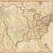
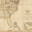
1816 Map of the United States with the contiguous British and Spanish Possessions
the Vintage Map Shop, Inc.
Regular price $65.00
Unit price per
By: John Melish
Date: June 6, 1816 (published) Philadelphia
Dimensions: 34.75 x 56.75 inches (88 x 144 cm)
This is a fine print reproduction of the 4th state of the first American map of what would become the continental United States, published just 10 years after the Lewis and Clark expedition. The map is often referred to as a visual embodiment of Manifest Destiny, the effort American expansionism, first advocated by Thomas Jefferson.
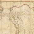
This remarkable map, known among collectors as the Melish map of America offers a unique view of what would become the continental United States just a decade after the culmination of the Lewis and Clark expedition (May 14, 1804 – Sep 23, 1806). The knowledge obtained from the expedition is show in detail that sharply contrasts the vast unexplored lands of present day California, Nevada, Utah, and Oregon, which was at the time regarded as Spanish Territory. Also detailed within the map are the notes and discoveries of Zebulon Pike's expedition to the Rockies (1806 - 1807).
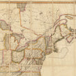
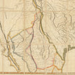
At the time of printing, America was on the move west, though the progress of civilization with bound to the the waterways of the Great Lakes, and the Ohio and Mississippi River. Illinois and Michigan are shown as territories. Other noteworthy territories include Mississippi, which in this map includes present day Alabama, the Missouri Territory that not only encompasses much of the western portion of America, but extends north into present day Canada, and the Northwest Territory that spans from present day northern Illinois (containing Chicago) up through Wisconsin, the Upper Peninsula of Michigan, Minnesota and part of what is now North Dakota.
While the 1755 Mitchell map of North America was instrumental in distinguishing geo-political borders of the 18th century and beyond, (most notably for its use during the 1783 Treaty of Paris) a similar comparison can be made for the Melish map and it's importance throughout the 19th century. One such example of the important role the map played in devising such boundaries can be found in Article V of the 1848 Treaty of Hidalgo Guadeloupe. The map was used to define a new U.S. / Mexico border that consisted of the Rio Grande northwest from its mouth to the point where it strikes the southern boundary of New Mexico (roughly 32 degrees north), then due west from this point to the 110th meridian west, then north along the 110th Meridian to the Gila River and down the river to its mouth.
As previously noted, the map was also utilized as a visual embodiment of Manifest Destiny. Thomas Jefferson referred to the map as "a luminous view of the comparative possessions of different powers in our America." Shortly after the publication of this map, the Anglo-American Convention of 1818 extended the U.S.-Canadian border westwards along the 49th parallel from the Lake of the Woods to the Rocky Mountains.Within the same treaty, the British and Americans agreed to jointly occupy the Oregon Country that at the time extended North of the 49th parallel into present day British Columbia. This treaty essentially guaranteed the United States a contiguous stretch of land from the Atlantic to the Pacific Ocean.
Inventory #11484