


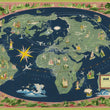

1967 Air France - Le Plus Grande Reseau du Monde
the Vintage Map Shop, Inc.
Regular price $45.00
Unit price per
By: Lucien Boucher
Date: 1967 (published) Paris
Original Size: 23 x 37.5 inches (58.5 x 95.25 cm)
This is a fine print reproduction of the 1967 edition from Lucien Boucher’s Air France world map series. This example is identified by the blue / green coloring of the land within a navy blue ocean. The series was initially funded by the French government to promote its national airline, Air France, in the government’s attempts to rebuild the French economy in the years following the disastrous consequences of WWII.
The map centers on Europe and Northern Africa, delineating the “long haul lines,” and “lines of other companies in correspondence,” to Air France. Aside from the ample service throughout Europe and the eastern Mediterranean, one can’t help but notice the intricate network of connections throughout French West Africa. The projection is functional with respect to showing the air routes without line breaks, but falls short of a true world map by failing to include, Australia, New Zealand, the southern portion of South America, Antarctica, and much of the Pacific.
Throughout the work, illustrations depict regional representations of culture, history, architecture, and nature. In the oceans, aspects of earlier maps can be seen in mythical creatures, sea monsters, and sailing tall ships from centuries past. Finally, the map is surrounded by a most decorative border illustrating people, cultures, flora and fauna from far reaches of the world; an element of the map that clearly pays homage to earlier cartographic works of the 16th and 17th century.
Lucien Boucher (1889-1971) started his career as a cartoonist for satirical magazines before focusing on poster artwork for film and advertising. He is best known for the series of Air France posters that he made between 1934 and 1962.
Inventory #11096
About Our Prints
Our prints are fine art reproductions created from original antique maps and vintage posters in our collection, dating back to over 500 years. Each image is professionally scanned, in some cases digitally restored, and carefully printed to preserve the detail, tone, and character of the original work.
- Printed from original maps and prints in our collection
- High-resolution scans for exceptional clarity and detail
- Produced on premium archival paper for long-lasting quality
- Rich color and sharp definition suitable for framing
- Includes a 0.25 inch margin for trimming or matting
- Made to order and securely packaged for safe delivery
Returns and Exchanges
Our prints are made to order, so returns and exchanges are handled within a simple 14-day window. If you need to return or exchange a print, we ask that it be sent back in its original, undamaged condition.
- Returns accepted within 14 days of delivery
- 25% restocking fee on non-damaged returns
- Buyer pays return shipping
- Refunds issued to the original payment method
- Size exchanges available, with shipping and applicable fees paid by the buyer