

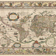
1631 Nova Totius Terrarum Orbis Geographica ac Hydrographica Tabula
The Vintage Map Shop, Inc.
Regular price $45.00
Unit price per
By: Willem Janszoon Blaeu
Date of Original: 1631 (published) Amsterdam
Original Size: 17.5 x 22 inches (44.5 x 56 cm)
This is a fine print reproduction of a true masterpiece world map from the Golden Age of Dutch Cartography. It is one of the earliest atlas maps to utilize the Mercator projection and one of the more ornate examples of world maps to have been created during that era. Blaeu’s map was first issued in an atlas and was used continuously by him, despite new knowledge of various parts of the world provided by explorers, until 1662.
The map is based on Blaeu’s monumental work dating to 1605 (circa), an oversize double-hemisphere world map of which only one copy is known to be extant. Dutch engraver Josua van de Ende reduced this grand map to standard atlas size for Blaeu, retaining and reflecting basically the same geographic information as the original. The map is both highly detailed and richly embellished, providing geographic and topographical information as well as beauty to the beholder.
Hand-coloured and double-paged with Latin text on the verso, the map depicts much more than the continents and oceans, and some of the geographic information is of especial interest, representing as it does vast regions of the planet which were yet ill defined as late as the 17th century. The great southern continent is still shown as extending across the entire southern portion of the map, with Tierra del Fuego depicted as part of it. Other geographic misrepresentations include the proportions of various areas of North and South America, including the elongated northwestern coast of North America. The sizes and shapes of land masses in the polar regions are significantly exaggerated. In the upper right corner in the polar region a brief text concerning the Russian region of Novaya Zemlya states: 'Novaya Zemlya (New Land). Discovered in 1596 by Willem Barentszoon from Amsterdam in the name of the States General of the Netherlands.’
Three decorative cartouches embellish the map, all with text in Latin. In the upper left quadrant, the largest of the three contains text stating, ‘America, in the year of our Lord 1492, was first discovered by Christopher Columbus for the king of Castille and was named for Amerigo Vespucci in 1499.’ The remaining cartouches also contain text in Latin, one providing geographic information and the other containing dedicatory and informative text regarding the production of the map. These cartouches are only one element of the decorative aspects of the map.
Along the top border its ornamentation consists of seven figures in oval-shaped vignettes containing allegorical representations of the sun and the moon along with five planets including Mercury, Venus, Mars, Jupiter and Saturn. To balance the top border, Blaeu used similarly shaped vignettes depicting the seven wonders of the ancient world: the Hanging Gardens of Babylon including the tower of Babel in the background, the Colossus of Rhodes, the Pyramids at Giza, the Mausoleum of Halicarnassus before it was destroyed by crusaders, the Temple of Goddess of the Hunt Artemis (Diana) at ancient Ephesus, the statue of Zeus (Jupiter) on Mount Olympus, and the Lighthouse of Alexandria.
The left border consists of four rectangular vignettes representing the four elements, and the right four corresponding in size and shape vignettes representing the four seasons. The vignettes come from works of famous Dutch artists at the end of the 16th century. A number of ships and sea creatures, and five compass roses further embellish the map.
Inventory #11738
About Our Prints
Our prints are fine art reproductions created from original antique maps and vintage posters in our collection, dating back to over 500 years. Each image is professionally scanned, in some cases digitally restored, and carefully printed to preserve the detail, tone, and character of the original work.
- Printed from original maps and prints in our collection
- High-resolution scans for exceptional clarity and detail
- Produced on premium archival paper for long-lasting quality
- Rich color and sharp definition suitable for framing
- Includes a 0.25 inch margin for trimming or matting
- Made to order and securely packaged for safe delivery
Returns and Exchanges
Our prints are made to order, so returns and exchanges are handled within a simple 14-day window. If you need to return or exchange a print, we ask that it be sent back in its original, undamaged condition.
- Returns accepted within 14 days of delivery
- 25% restocking fee on non-damaged returns
- Buyer pays return shipping
- Refunds issued to the original payment method
- Size exchanges available, with shipping and applicable fees paid by the buyer