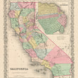

1856 California
The Vintage Map Shop
Regular price $35.00
Unit price per
By: Joseph H. Colton
Date of Original: 1856 (published) New York
Original Size: 16 x 13 inches (40.5 x 33 cm)
This is a fine print reproduction of a map of California, published by Joseph H. Colton out of New York in 1856. The map is color coded by county and shows railroads, common roads, rivers, canals, ports, lakes, forts, large towns and villages of the mid-19th century. The map also includes a detailed inset map of the city of San Francisco colored by ward and detailing the growth of the city extending into the Bay of San Francisco. other noteworthy cities and towns found within the map include San Diego, Los Angeles, Santa Barbara, Monterey, Stockton, Sacramento, Nevada City, and Shasta City to name a few. The state of California is bordered to the east by the Territory and Utah and New Mexico instead of Nevada.
Published just sever years after the discovery of gold at Sutter's mill in 1849, much of the population resides between San Francisco and gold country. Many counties in this map will later be reconfigured, divided, and renamed. Within the central valley west of the Sierra Nevada mountains is a long stretch of marsh land along the San Joaquin River that feeds Tulare Lake. Contrasting this map with the ongoing drought the state suffers from today adds to the intrigue of this map.
Inventory #NA160

