




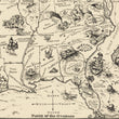

1926 Bootlegger's Map of the United States
The Vintage Map Shop, Inc.
Regular price $45.00
Unit price per
Bootlegger's Map of the United States
By: Edward McCandlish Published By: Griswold Press
Date of Original: 1926 (cpublished) Detroit
Original Size: 21.5 x 33.75 inches (54.6 x 85.75 cm)
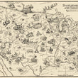
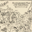
This is a fine print reproduction of an early example of the iconic Bootlegger's Map, created as a parody on the Volstead Act that brought about the prohibition era of the 1920s and sharp rise in power and influence of organized crime across America.
This awe-inspiring pictorial map was originally published in the Washington Post by a staff cartoonist Edward Gerstell McCandlish (1887 - 1946) who at the time was known for his illustrated a Sunday column "Bunny Tots." The satirical map caught the attention of many, including the Griswold Press in Detroit Michigan of which this example was published. Detroit and the rest of the state of Michigan had a long-standing experience with prohibition as it had passed the Damon Law of 1917, which prohibited the bringing or carrying into the state, or the receipt or possession of any intoxicating liquors.
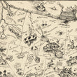
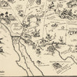
The map features a wide array of whimsical pictographs, mocking places and cultures throughout the United States with a common theme of beer, wine, and spirits. Nearly every placename is written as a play-on-words such as Chi-Keg-O, Albu-Corky, spo-Can, Vir-GIN-ia, and Port-Land to name a few. The map features a scale of distance in pints, and a compass rose with "Pints of the Compass" reading "Norse," "Souse," "Yeast," and "Wets." The "12 (nautical) Mile Limit" of the territorial sea in which the U.S. Coast Guard had jurisdiction is delineated in the Pacific and Atlantic by a string of floating kegs or barrels (suggestively containing alcohol).
Other imagery is very indicative of the 1920s. For example, in Florida there are two signs reading "Real Estate," and "Lots for Sale," representing the speculative land boom and real estate bubble that brought about the creation of new cities out of the Everglades, hasty construction of flimsy homes and stores, and numerous failed development projects, which ultimately shaped the future of Florida for decades to come.
The Bootlegger's Map of the United States has gone down as one of the "must-have" pictorial maps of the 20th century. It has been reproduced several times over by other publishing companies in slightly altered forms and later with color. This example lacking a copyright date suggests that it may be a very early example and possibly a pre-publication or proof state.
Inventory #11969
About Our Prints
Our prints are fine art reproductions created from original antique maps and vintage posters in our collection, dating back to over 500 years. Each image is professionally scanned, in some cases digitally restored, and carefully printed to preserve the detail, tone, and character of the original work.
- Printed from original maps and prints in our collection
- High-resolution scans for exceptional clarity and detail
- Produced on premium archival paper for long-lasting quality
- Rich color and sharp definition suitable for framing
- Includes a 0.25 inch margin for trimming or matting
- Made to order and securely packaged for safe delivery
Returns and Exchanges
Our prints are made to order, so returns and exchanges are handled within a simple 14-day window. If you need to return or exchange a print, we ask that it be sent back in its original, undamaged condition.
- Returns accepted within 14 days of delivery
- 25% restocking fee on non-damaged returns. Due to lack of storage, larger sizes may incur a higher restocking fee, up to 50%.
- Buyer pays return shipping
- Refunds issued to the original payment method
- Size exchanges available, with shipping and applicable fees paid by the buyer