


1856 Geological and Paleontological Map of the British Isles
The Vintage Map Shop
Regular price $60.00
Unit price per
By: Alexander K. Johnston
Date of Original: 1854 (dated) Edinburgh
Original Size: 41 x 25 inches (104 x 63.5 cm)
This is a fine print reproduction of a two-sheet map joined to make one remarkable Geological and Paleontological map of the British Isles. They were published in the second edition of Johnston's Physical Atlas of Natural Phenomena, out of Edinburgh by William Blackwood & Sons in 1856.
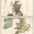
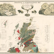
Johnston composed the maps using sketches and notes of Professor Edward Forbes, F.R.S. of Kings College London. and illustrated them lavishly. The skull and antlers of an Irish elk are at top center of the first map. Between the antlers is the heading 'Tertiary and Post Tertiary Tertiary Mammalia'. Fossils of other ancient mammalian creatures are depicted nearby including hyena, mammoth and cave lion, all of which had lived in the British Isles and whose fossils have been found there.
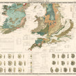
To the left of the center illustrations are images of various fish fossils dating to the Pleistocene Era. The upper right contains images of fossilized vertebrates labeled 'Secondary Reptiles. Below these images is a map of the northern portion of the British Isles. The second map features the lower portion of the Isles and is also beautifully illustrated. The region covered is approximately the lower half of the Isles. The fossils depicted are groups of ammonites, which he states are primarily 'Lower Secondary'. Both maps feature numerous insets with scientific information regarding the features depicted in the maps, and much information regarding the life of past geologic periods as known from fossil remains.
Alexander Keith Johnston's Physical Atlas of Natural Phenomena was one of the most comprehensive geographic works of its time to focus on natural science. Johnston described the motivations and focus of his work in the preface as follows; The object originally contemplated in this work was to present, in a graphic form, a concise yet comprehensive view of the Physical Geography of the Globe, embracing under that term its superficial structure, the movements of its aerial and oceanic currents, and the distribution of organized existence on its surface.
Inventory #12557
About Our Prints
Our prints are fine art reproductions created from original antique maps and vintage posters in our collection, dating back to over 500 years. Each image is professionally scanned, in some cases digitally restored, and carefully printed to preserve the detail, tone, and character of the original work.
- Printed from original maps and prints in our collection
- High-resolution scans for exceptional clarity and detail
- Produced on premium archival paper for long-lasting quality
- Rich color and sharp definition suitable for framing
- Includes a 0.25 inch margin for trimming or matting
- Made to order and securely packaged for safe delivery
Returns and Exchanges
Our prints are made to order, so returns and exchanges are handled within a simple 14-day window. If you need to return or exchange a print, we ask that it be sent back in its original, undamaged condition.
- Returns accepted within 14 days of delivery
- 25% restocking fee on non-damaged returns
- Buyer pays return shipping
- Refunds issued to the original payment method
- Size exchanges available, with shipping and applicable fees paid by the buyer