


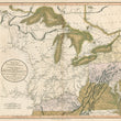

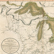
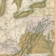
1805 Map of Part of the United States of North America, Exhibiting the Western Territory, Kentucky, Penssylvania, Mayland, Virginia & also the Lakes Superior, Michigan, Huron, Ontario & Erie.
the Vintage Map Shop
Regular price $40.00
Unit price per
A New Map of Part of the United States of North America, Exhibiting the Western Territory, Kentucky, Penssylvania, Mayland, Virginia &c. also the Lakes Superior, Michigan, Huron, Ontario & Erie.
By: John Cary
Date of Original1805 (dated) London
Size of Original: 19 x 21 inches (48 x 53 cm)
A fine print reproduction of one of the last maps to depict the Northwest Territory in its entirety before its division into states and smaller territories. Although Ohio achieved statehood in 1803, the map reflects the publication delays common in early nineteenth-century cartography, making it among the final representations of the original territorial framework.
Established in 1787, the Northwest Territory encompassed lands northwest of the Ohio River, extending to Lake Superior and west to the Mississippi River. Over the following decades, it was divided into the states of Ohio, Indiana, Michigan, Illinois, and Wisconsin, representing the first major wave of western settlement after the American Revolution and setting the stage for continued westward expansion.
The map presents excellent cartographic detail, including Native American villages, boundary lines, treaties, forts, early settlements, fur trading posts, forests, rivers, roads, and portage routes. Of particular note is the nine-mile portage between the Wabash and Miami Rivers near Fort Wayne, a vital trading link between Lake Erie and the Ohio River system.
Early land companies such as the Illinois, Jersey, and Wabash Companies are identified, while Kentucky appears in detail shortly after statehood, with references to early settlement associated with Daniel Boone. The Appalachian Mountains, labeled the Cumberland or Great Laurel Mountains, are finely rendered, and present-day West Virginia, shown as Virginia, reflects early and unrealized plans for the proposed colony of Vandalia.
The map presents strong visual record of a formative period in American territorial development and one of the most detailed depictions of the historic Northwest Territory.
Inventory #12353
About Our Prints
Our prints are fine art reproductions created from original antique maps and vintage posters in our collection, dating back to over 500 years. Each image is professionally scanned, in some cases digitally restored, and carefully printed to preserve the detail, tone, and character of the original work.
- Printed from original maps and prints in our collection
- High-resolution scans for exceptional clarity and detail
- Produced on premium archival paper for long-lasting quality
- Rich color and sharp definition suitable for framing
- Includes a 0.25 inch margin for trimming or matting
- Made to order and securely packaged for safe delivery
Returns and Exchanges
Our prints are made to order, so returns and exchanges are handled within a simple 14-day window. If you need to return or exchange a print, we ask that it be sent back in its original, undamaged condition.
- Returns accepted within 14 days of delivery
- 25% restocking fee on non-damaged returns
- Buyer pays return shipping
- Refunds issued to the original payment method
- Size exchanges available, with shipping and applicable fees paid by the buyer