


1856 Philadelphia
The Vintage Map Shop
Regular price $35.00
Unit price per
By: Joseph H. Colton
Date of Original: 1856 (published) New York
Original Size: 14 x 17 inches
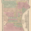
This fine print reproduction showcases an 1856 plan of Philadelphia originally published by the acclaimed American mapmaker Joseph H. Colton as part of his 1856 Atlas of the World.
Colton’s city plan is richly detailed and hand-colored by ward, delineating the urban grid with named streets, docks and piers along the Delaware and Schuylkill rivers, railroads, public buildings, university grounds, parks, and cemeteries, all framed within his signature decorative border and distance scale at bottom center. The map’s clarity and precision reflect Colton’s reputation for high-quality engraving and comprehensive city charts during the mid-19th century.
In the mid-1850s, Philadelphia was undergoing major transformation following the Act of Consolidation of 1854, which unified the city with all of Philadelphia County and greatly expanded its boundaries. This reorganization brought rapidly growing neighborhoods under a single municipal government at a time when Philadelphia ranked among the largest cities in the United States.
The city had evolved from an early port town into a major industrial and transportation center, with railroads, canals, and improved road networks linking it to the interior and driving manufacturing growth. The expansion of universities, hospitals, and landscaped cemeteries such as Laurel Hill reflects changing urban planning and social infrastructure, while Colton’s 1856 plan captures Philadelphia at a pivotal moment on the threshold of modern urban development.
Inventory #NA119
About Our Prints
Our prints are fine art reproductions created from original antique maps and vintage posters in our collection, dating back to over 500 years. Each image is professionally scanned, in some cases digitally restored, and carefully printed to preserve the detail, tone, and character of the original work.
- Printed from original maps and prints in our collection
- High-resolution scans for exceptional clarity and detail
- Produced on premium archival paper for long-lasting quality
- Rich color and sharp definition suitable for framing
- Includes a 0.25 inch margin for trimming or matting
- Made to order and securely packaged for safe delivery
Returns and Exchanges
Our prints are made to order, so returns and exchanges are handled within a simple 14-day window. If you need to return or exchange a print, we ask that it be sent back in its original, undamaged condition.
- Returns accepted within 14 days of delivery
- 25% restocking fee on non-damaged returns
- Buyer pays return shipping
- Refunds issued to the original payment method
- Size exchanges available, with shipping and applicable fees paid by the buyer