


1828 Mappa de los Estados Unidos de Mejico...
The Vintage Map Shop, Inc.
Regular price $65.00
Unit price per
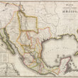
Mappa de los Estados Unidos de Mejico, segun lo organazido y definido por las varias actas del Congreso de dicha Republica y construido por las mejores autoridades.
By: White, Gallaher, & White
Date of Original: 1828 (dated ) New York
Original Size: 41 x 29 inches (104 x 71 cm)
This is a fine print reproduction of a rare first edition map (in Spanish) of what would be known as the "Treaty Map of the Mexican-American War." This map would prove to be an instrumental piece to the Treaty of Guadaloupe Hidalgo and is the first in a series of maps to define the border between Mexico and the United States of America.
This fascinating map presents all of Mexico when it was at it's greatest size. Much of the land north and to the west of the Rio Grande however would fall under conflict between the Texans and Unites States in the coming decades, ultimately reducing the size of Mexico by nearly half. The War of Texas Independence, would be fought from October 1835 to April 1836. and the Mexican-American War would follow just a decade later from April 25, 1846 to February 2, 1848. A later reprinting of this map (wqith some notable changes) by John Distrunell would be utilized during the Treaty of Guadaloupe Hidalgo, signed on February 2, 1848, ending the Mexican-American War. This map is considered among collectors and scholars as the first of a series of maps that would ultimately define the border between Mexico and the United States.
Early routes of trade, commerce, and emigration such as the Santa Fe Trail, and El Camino Real are delineated within the map, connecting both Mexico City, and the western-most outpost of the United States (Fort Osage) to the historic and pivotal town of Santa Fe. Locations of numerous Native American tribes are found throughout the map, including the Apaches and Navajos, both of which had been at war with first the Spanish Conquistadores, and then the Mexicans for centuries.
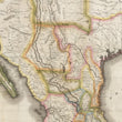
Texas is shown in its pre-revolution state at a time when there were only a few thousand Americans that had settled there. After the Mexican Revolution of 1824, the Mexican government needed settlers to protect it from foreign invasion, and they offered liberal land grants to anyone who would become citizens and accept the Catholic faith. Eventually, American immigrants in Texas outnumbered the Mexicans and a series of events led to the Texan Revolution. In this map, the only town of significance is San Antonio.
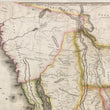
The cartography of "Alta California" features numerous cartographic errors including the overall delineation of the coastline, and two large rivers that appear to be sourced from major inland lakes, one of which is in the place of the Great Salt Lake. There is no representation of the Sierra Nevada Mountains or the Grand Canyon, nor would there be until the latter half of the 19th Century.
The lower left portions of the map features an extensive table of distances, a table of statistics that includes the population, size (in square miles) and a geographical description of each state in Mexico. Just below these tables is an inset map titled "Carta de los Caminos &c. Desde Vera Cruz y Alvarado a Mejico," which as the title suggests, shows the major roads between Mexico City and Vera Cruz on the gulf coast. This is a centuries-old network of roads dating back to and arguably before the arrival of Hernán Cortés in 1521.
Inventory #11909
About Our Prints
Our prints are fine art reproductions created from original antique maps and vintage posters in our collection, dating back to over 500 years. Each image is professionally scanned, in some cases digitally restored, and carefully printed to preserve the detail, tone, and character of the original work.
- Printed from original maps and prints in our collection
- High-resolution scans for exceptional clarity and detail
- Produced on premium archival paper for long-lasting quality
- Rich color and sharp definition suitable for framing
- Includes a 0.25 inch margin for trimming or matting
- Made to order and securely packaged for safe delivery
Returns and Exchanges
Our prints are made to order, so returns and exchanges are handled within a simple 14-day window. If you need to return or exchange a print, we ask that it be sent back in its original, undamaged condition.
- Returns accepted within 14 days of delivery
- 25% restocking fee on non-damaged returns
- Buyer pays return shipping
- Refunds issued to the original payment method
- Size exchanges available, with shipping and applicable fees paid by the buyer