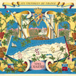

1950 Les Vignobles de France | Vins d'Algerie.
the Vintage Map Shop, Inc.
Regular price $45.00
Unit price per
By: Remy Hetreau
Date of Original: 1954 (published) France
Original Size: 25.5 x 31 inches (64.75 x 78.75 cm)
This is a fine print reproduction of a marvelous promotional travel poster from 1950. It was part of a series of maps commissioned by the Comite National de Propagande en Faveur du Vin to celebrate and promote the legendary wine regions of France. French artist, illustrator and print maker, Remy Hetreau took on this task, creating some magnificent posters highlighting local wineries of eight different regions.
The title is contained in a ribbon cartouche at the top of the map. A beautiful vineyard scene fills the top portion of the map presenting an Algerian chateaux topped with a crescent moon nestled among vineyards with mountains in the background. Aside from the grape vines and numerous crests, the map features crated barrels ready to be shipped across the Mediterranean to southern France. Two ship masts with furled sails and the French flag rise prominently above the map. A combination of pink, red and white grapes are depicted among vineyards that stretch from Oran to Constantine.
Algeria has an interesting and often overlooked history with respects to French wine making. When Algeria came under French rule in 1830 vineyards were replanted in order to serve the needs of the local pieds-noir, which refers to people of French and European ancestry born in Algeria. When the phylloxera epidemic destroyed the French vineyards in the mid-19th century (around the time of this maps' publication), Algerian wine exports into France filled the void. Today, very little wine is produced in the region.
Inventory #10772

