




1865 Topographical Map of the City of New York...
The Vintage Map Shop, Inc.
Regular price $70.00
Unit price per
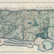
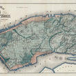
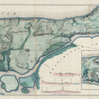
Topographical Map of the City of New York. Showing Original Water Courses and Made Land.
By: Egbert L. Viele
Original Date: 1865
Size of Original: 18.5 x 2.6 inches (47 x 160 cm)
This map is a fine print reproduction of one of the scarcest, most important and most enduring maps of New York City ever published.
Viele's map covers Manhattan Island in its entirety and details the canals, swamps, rivers, ditches, ponds, meadows, and drainage basins of Manhattan as they existed prior to the city's urban development. The map is so accurate that a version of it is used to this day by architects and contractors who need to ascertain the location of underground rivers and swamps which might destabilize foundations of new construction projects.
The map was twenty years in the making as Viele consulted original sources such as plans, older maps, and surveys in his quest to create a dependable and accurate reference, even consulting the first maps depicting the island as it was when the first Dutch settlers built a fur trading post on the tip of the island. Viele's efforts resulted in this map, a masterpiece of its kind.
- Please contact us for larger / custom sizes.
Inventory #81031
About Our Prints
Our prints are fine art reproductions created from original antique maps and vintage posters in our collection, dating back to over 500 years. Each image is professionally scanned, in some cases digitally restored, and carefully printed to preserve the detail, tone, and character of the original work.
- Printed from original maps and prints in our collection
- High-resolution scans for exceptional clarity and detail
- Produced on premium archival paper for long-lasting quality
- Rich color and sharp definition suitable for framing
- Includes a 0.25 inch margin for trimming or matting
- Made to order and securely packaged for safe delivery
Returns and Exchanges
Our prints are made to order, so returns and exchanges are handled within a simple 14-day window. If you need to return or exchange a print, we ask that it be sent back in its original, undamaged condition.
- Returns accepted within 14 days of delivery
- 25% restocking fee on non-damaged returns. Due to lack of storage, larger sizes may incur a higher restocking fee, up to 50%.
- Buyer pays return shipping
- Refunds issued to the original payment method
- Size exchanges available, with shipping and applicable fees paid by the buyer