


1733 A Map of the British Empire in America... | Peel & Stick Wall Mural
The Vintage Map Shop, Inc.
Regular price $400.00
Unit price per
A Map of the British Empire in America with the French and Spanish settlements adjacent thereto.
By: Henry Popple
Date: 1733 / 1735 (Published) London
Original Size: 8.2 x 7.5 feet (98 x 94 inches)
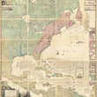
This is a fine print reproduction offered as a peel & stick wall mural of a monumental 18th century map of colonial America by Henry Popple. The large twenty sheet map is widely considered to be one of the two most important large format maps concerning the history and geography of North America during the 18th century, a time when Europe’s greatest military powers were in a constant struggle against one another to dominate the new world.
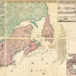
The map, when joined stands at just over 8 feet tall and 7.5 feet wide and is filled from end to end with the most accurate cartographic information of the time. The cartographic information presented in the map was so impressive that it even earned the endorsement of Dr. Edmund Haley, professor of Astronomy at Oxford. At the time of printing, Halley was the second Royal Astronomer of Britain, succeeding John Flamsteed in 1720. His words appear at in the lower right sheet.
- I have seen the abovementioned Map, whish as far as I am Judge, seems to have been laid down with great Accuracy, and to theru the Position of the different Provinces & Islands in that part of the Globe more truly than any yet extant. – Edmund Halley
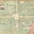
When first published, Popple’s map was not a great success. In 1727 he began working with the Board of Trade and Plantations to help settle boundary disputes between British colonists and the French. By 1730, the Board began requesting detailed maps of the region. Popple announced that he had commenced work on this map in 1731 and ultimately completed his work by 1733, however the sales just weren’t there. He sold production rights of the map to Samuel Harding and William H. Toms in 1739, right at the “War of Jenkins’ Ear,” formally began. While the origins of the name of the war are interesting, they are not relevant to this map. The conflict dates back to 1731 when a Spanish privateer severed British captain Robert Jenkins's ear as punishment for raiding Spanish ships. As the English wanted retribution for this act, tensions rose between the two powers and conflict over land soon began in present day Georgia. This map is the first map to present the colony of Georgia, which was chartered in London in July of 1732. Soon thereafter
James Edward Oglethrope landed in the region with 120 colonists and reported back to England in 1734 with several maps, sea charts, and sketches of the new colony, to which Henry Popple incorporated into his map. The inclusion of the Colony of Georgia did several things. First, is moved the official boundary of the British colonies further south to Florida, which was under Spanish control at the height of the “War of Jenkins’ Ear.” This inclusion of the new colony added an extra layer of protection for the more well-established colonies to the north. Back then the northern colonies were more heavily fortified, so land and distance was a useful advantage in terms of protection and defense for the southern colonies. The inclusion of Georgia also makes Popple’s map the first map to show all of the thirteen colonies that would eventually convene in Philadelphia to sign the Declaration of Independence from Great Britain.
When one views the monumental work they can be drawn in to the fine detail throughout or observe the map as a whole. Both methods achieve important visual distinctions. As noted by Edmund Halley the map is remarkably detailed and accurate as Popple drew from a wide array of sources, both well established by other map makers and new information from the very people that inhabited North America. Nearly every single town and settlement is accurately located along with the wide array of Native American tribes that dominated the continent at the time of printing.
What Popple did with the color coding of his map cannot be understated. He made territory claimed by the Dutch Red/Purple, the Spanish is Yellow, the English Red, Indian lands are Green, and the French lands Blue. Now, when one looks at the map, it can be difficult to find the blue color representing French controlled land. That is because it only appears in thin lines along the southern stretch of the Mississippi and the northern bank of the St. Laurence River, thus by comparison to the British colonies seems miniscule and insignificant. This began a multiple-decade’s long run of maps by both the French and English where the presentation of “their territory” dwarfs that of the other.
Though Henry Popple’s map was presented to the world with little enthusiasm, it is now regarded as an extraordinary achievement and was relentlessly copied by his contemporaries not only in England, but throughout the ever-important trade of European map makers. Today, it is commonly referred to as one of two most important maps of Colonial America.
Inventory #11680
NOTE: THIS PRODUCT IS ONLY AVAILABLE AS A PEEL & STICK WALL MURAL
About Our Prints
Our prints are fine art reproductions created from original antique maps and vintage posters in our collection, dating back to over 500 years. Each image is professionally scanned, in some cases digitally restored, and carefully printed to preserve the detail, tone, and character of the original work.
- Printed from original maps and prints in our collection
- High-resolution scans for exceptional clarity and detail
- Produced on premium archival paper for long-lasting quality
- Rich color and sharp definition suitable for framing
- Includes a 0.25 inch margin for trimming or matting
- Made to order and securely packaged for safe delivery
Returns and Exchanges
Our prints are made to order, so returns and exchanges are handled within a simple 14-day window. If you need to return or exchange a print, we ask that it be sent back in its original, undamaged condition.
- Returns accepted within 14 days of delivery
- 25% restocking fee on non-damaged returns
- Buyer pays return shipping
- Refunds issued to the original payment method
- Size exchanges available, with shipping and applicable fees paid by the buyer