


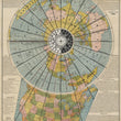
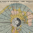

1906 The Pheil's Universal Time Indicator
The Vintage Map Shop
Regular price $45.00
Unit price per
By: Isaac F. Pheil
Date of Original: 1906 (dated) Toledo, Ohio
Original Size: 30 x 22 inches (76 x 56 cm)
This is a fine print reproduction of a 1906 map, created by The Toledo Blade newspaper, showcases an innovative depiction of global time zones using a polar projection centered on the North Pole.
The design features radiating longitudinal lines, with countries and regions labeled along the edges, and a rotating volvelle at its center. This clock-like mechanism, marked with "AM" and "PM" designations, allows users to easily determine local time in any part of the world, emphasizing the Earth's rotation and the relationship between time zones and Greenwich Mean Time (GMT).
Developed in an era of rapid advancements in transportation and communication, the map reflects the adoption of standardized time zones, a system formalized at the 1884 International Meridian Conference. It highlights the global synchronization of timekeeping, including the International Date Line, which regulates calendar changes across the Pacific. The detailed depiction of U.S. time zones underscores the map’s practical use for travelers and businesses navigating the interconnected world.
Pheil’s map exemplifies the technological optimism of the early 20th century, representing a world increasingly unified by shared systems and innovations. While modern technology has simplified global timekeeping, this artifact serves as a historical reminder of the challenges and achievements in managing time across a globalized society.
Inventory #12875
About Our Prints
Our prints are fine art reproductions created from original antique maps and vintage posters in our collection, dating back to over 500 years. Each image is professionally scanned, in some cases digitally restored, and carefully printed to preserve the detail, tone, and character of the original work.
- Printed from original maps and prints in our collection
- High-resolution scans for exceptional clarity and detail
- Produced on premium archival paper for long-lasting quality
- Rich color and sharp definition suitable for framing
- Includes a 0.25 inch margin for trimming or matting
- Made to order and securely packaged for safe delivery
Returns and Exchanges
Our prints are made to order, so returns and exchanges are handled within a simple 14-day window. If you need to return or exchange a print, we ask that it be sent back in its original, undamaged condition.
- Returns accepted within 14 days of delivery
- 25% restocking fee on non-damaged returns
- Buyer pays return shipping
- Refunds issued to the original payment method
- Size exchanges available, with shipping and applicable fees paid by the buyer