

1855 Map No. 2 From the Northern Boundary of California to the Columbia River
The Vintage Map Shop, Inc.
Regular price $45.00
Unit price per
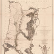
Map No. 2 From the Northern Boundary of California to the Columbia River from explorations and surveys made under the direction of Hon. Jefferson Davis. Sec. of War
By: Lieuts. R.S. Williamson and H.L. Abbot
Date of Original: 1855 (dated) U.S. Pacific Railroad Surveys
Original Size: 28.5 x 24 inches (72.5 x 61 cm)
This is a fine print reproduction of a mid-19th century map of the Oregon Territory that is both impressive in detail while igniting a sense of adventure with regards to several places noted as "Unexplored." The map covers the region from the Siskoyou Range and Klamath Lakes north to Mount St. Helens and Mount Adams, just above the Columbia River.
As noted above the title, the map was made for the U.S. Department of War to present the explorations and surveys of the area for a railroad route that would run from the Mississippi River to the Pacific Ocean.
An interesting notation providing pertinent information for any potential railroad reads "Heavily timbered Ridged separated by immense ravines," can be found along the western side of the Cascade Range. Additionally, this map delineates the emigrant road, various routes of the surveying parties, the historical routes of Fremont and Warner, some of the earliest settlements and young would be cities of Eugene and Portland.
Inventory #11400
About Our Prints
Our prints are fine art reproductions created from original antique maps and vintage posters in our collection, dating back to over 500 years. Each image is professionally scanned, in some cases digitally restored, and carefully printed to preserve the detail, tone, and character of the original work.
- Printed from original maps and prints in our collection
- High-resolution scans for exceptional clarity and detail
- Produced on premium archival paper for long-lasting quality
- Rich color and sharp definition suitable for framing
- Includes a 0.25 inch margin for trimming or matting
- Made to order and securely packaged for safe delivery
Returns and Exchanges
Our prints are made to order, so returns and exchanges are handled within a simple 14-day window. If you need to return or exchange a print, we ask that it be sent back in its original, undamaged condition.
- Returns accepted within 14 days of delivery
- 25% restocking fee on non-damaged returns
- Buyer pays return shipping
- Refunds issued to the original payment method
- Size exchanges available, with shipping and applicable fees paid by the buyer