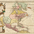

1710 L'Amerique Septentrionale Divisee En Ses Principales...
The Vintage Map Shop
Regular price $45.00
Unit price per
By: Alexis Hubert Jalliot
Date: 1710 (circa) Paris
Original Size: 23 x 35 inches (58.5 x 89 cm)
This is a fine print reproduction of an authentic, antique map of North America by Alexis Hubert Jalliot. The first state of the original map was published in Paris circa 1692 and then updated thereafter. This print is made from an example that dates to 1710.
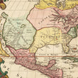
This early map of the North American continent focuses on European possessions and the Native American habitation that existed at the turn of the 18th century. Lovely colors define the territories of the east coast as Nouvelle France, N.Angleterre, N.Suede, Virginie, Floride Francoise and Floride. The great lakes are shown to consist of 6 bodies of water with which Ontario is fed by a separate branch of the St. Laurence, and Erie is depicted as landlocked. A possible Northwest Passage is indicated through Button’s Bay and California is mapped as an island. In the west, a series of Indian tribes are shown to reside between two mountain ranges and along the “River of the North,” which is fed by a large nameless lake.
Adorning the map is a large, elaborate title cartouche flanked by indigenous warriors and surrounded flora and fauna found within the new world. Two other warriors rest on either side of a distance cartouche containing eight various mileage scales. Both cartouches boast exceptional original color and gold accents.
Inventory #18691

