


1936 Big Game Fish, Complete Map Illustrated, Fresh and Salt Water Fishing.
The Vintage Map Shop, Inc.
Regular price $85.00
Unit price per
By: Joe Godfrey, Jr. & Gordon Ertz
Date of Original: 1936 (copyrighted) Chicago
Original Size: 28 x 30 inches (71 x 76 cm)
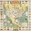
This is a fine print reproduction of a vintage fishing map of North America, originally published by Joe Godfrey Jr. out of Chicago in 1936. The map is a sure catch for any avid fisherman as it illustrates and locates many of the popular game fish sought out by anglers.
With over 56 varieties of fish illustrated in the borders, this pictorial map depicts fishermen in waders, on boats, or even horseback with a hooked fish. Several text boxes provide 1930s records for various fish caught throughout the world. Additional round inset maps at the lower left show Panama, the Hawaiian Islands, New Zealand, and Tahiti, with listings of the fish found in those waters. Additional inset text blocks list "Twenty-two World-famous Places to Go Fishing," "Famous Fishing Tournaments," and "Famous Big Game Fishing Clubs."
This map is perfect for any active fisherman or fisherwoman whether they enjoy angling, fly fishing, bank fishing, boat fishing, deep water, fresh water, or salt water. Though nearly 100 years have passed since this map was first produced, there have been very few produced since can that compare in detail and beauty.
Inventory #81071
About Our Prints
Our prints are fine art reproductions created from original antique maps and vintage posters in our collection, dating back to over 500 years. Each image is professionally scanned, in some cases digitally restored, and carefully printed to preserve the detail, tone, and character of the original work.
- Printed from original maps and prints in our collection
- High-resolution scans for exceptional clarity and detail
- Produced on premium archival paper for long-lasting quality
- Rich color and sharp definition suitable for framing
- Includes a 0.25 inch margin for trimming or matting
- Made to order and securely packaged for safe delivery
Returns and Exchanges
Our prints are made to order, so returns and exchanges are handled within a simple 14-day window. If you need to return or exchange a print, we ask that it be sent back in its original, undamaged condition.
- Returns accepted within 14 days of delivery
- 25% restocking fee on non-damaged returns
- Buyer pays return shipping
- Refunds issued to the original payment method
- Size exchanges available, with shipping and applicable fees paid by the buyer