

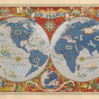

1952 Air France - Le Plus Grand Reseau Du Monde
The Vintage Map Shop
Regular price $45.00
Unit price per
By: Lucien Boucher
Date: 1952 (published) Paris
Original Size: 23 x 37.5 inches (74 x 107 cm)
This is a marvelous reproduction of a poster from an Air France series created by artist Lucien Boucher, showing an elongated terrestrial globe with Air France routes in white, surrounded by a richly decorated border of landscapes. The poster shows all destinations of Air France at the time, and describes them pictorially. While a few geographical features such as mountains and forested regions are included, the poster primarily focuses on cultural representations of the designated destinations.This nostalgic poster reminds us of the world before globalization had taken hold, before cultural blending or greying had advanced to its current state.
An enormous and colorful compass rose in the southern Atlantic orients us. Depictions of destinations in North America include the Capitol Building in Washington, DC, the Statue of Liberty just off the shore from New York, an Indian with a peace pipe standing before his tepee, and an Eskimo with a sledge and dog team in Canada. Africa's great diversity of cultures is amply illustrated, with Bedouins and indigenous peoples in native dress. Architectural elements are featured in Egypt, and an enormous elephant with marvelous trunks advances toward us.
Other destinations show famous landmarks and cultural icons such as the Kremlin for Moscow, a dragon for China, and a geisha for Japan. Turtles, a whale and a sea monster, and frigates embellish the oceans. A fanciful version of Pegasus suggests the magic element once associated with flying.
Inventory #81001
About Our Prints
Our prints are fine art reproductions created from original antique maps and vintage posters in our collection, dating back to over 500 years. Each image is professionally scanned, in some cases digitally restored, and carefully printed to preserve the detail, tone, and character of the original work.
- Printed from original maps and prints in our collection
- High-resolution scans for exceptional clarity and detail
- Produced on premium archival paper for long-lasting quality
- Rich color and sharp definition suitable for framing
- Includes a 0.25 inch margin for trimming or matting
- Made to order and securely packaged for safe delivery
Returns and Exchanges
Our prints are made to order, so returns and exchanges are handled within a simple 14-day window. If you need to return or exchange a print, we ask that it be sent back in its original, undamaged condition.
- Returns accepted within 14 days of delivery
- 25% restocking fee on non-damaged returns. Due to lack of storage, larger sizes may incur a higher restocking fee, up to 50%.
- Buyer pays return shipping
- Refunds issued to the original payment method
- Size exchanges available, with shipping and applicable fees paid by the buyer