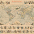


1900 Le Petit Journal Mappemonde
The Vintage Map Shop
Regular price $45.00
Unit price per
By: F. Menetrier
Date: 1900 (circa) Paris
Original Size: 36 x 43 inches (91.5 x 109 cm)
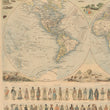
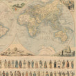
This is a colorful and informative eye-catching reproduction of a renowned and rare poster by F. Menetrier dating to the year 1900. This incredible map shows shipping routes and sailing times to destinations in many places around the world. Transport had changed considerably following the Industrial Revolution, and this map illustrates the extent to which different modes of sea transport had effectively connected all the ports of the world, one to another, how the world had in effect been made smaller by this means.
This is also a sophisticated world map of its time, showing all countries and important cities, geographical and topographical features, along with the countless sea routes which started the trajectory which eventually became globalization. Over sixty figures of people in native costumes and a number of decorative vignettes further embellish the map.
Inventory #81003


