

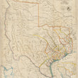

1841 A Map of Texas, compiled from Surveys recorded in the Land Office of Texas, and other Official Surveys.
the Vintage Map Shop, Inc.
Regular price $45.00
Unit price per
Iconic Map of Texas as a Republic or Independent Country
By: John Arrowsmith
Date: 1841 (published) London
Original Size: 24.5 x 20.5 inches (62 x 52 cm)
A fine print reproduction of a landmark map of Texas as a Republic in its largest form. The map was originally published by the esteemed English Geographer, John Arrowsmith in his famous London Atlas.
The latest geographic information for the map was sourced from four years of study by the General Land Office of Texas. The map included directional breaks in the upper reaches of river systems, complete with descriptive remarks such as "Good Prairie," "Rich Land Well Timbered," and "Valuable Game." It locates numerous Native American tribes of which the Comanche and two variant Apache tribes occupied the Big Bend region of Southwest Texas.
At the time of the maps printing in 1841, Texas had just achieved its independence from Mexico and was its own republic. This new Republic was much large than present day Texas, extending as far west to include Santa Fe and well north into the Colorado Rockies. At the bottom of the map are two insets, one of which centers on Galveston Bay, complete with depth sounding and shallow bank locations.
This map of Texas is widely regarded among the antiquarian map collecting community as the holy grail of Texas maps. Originals have sold for over $70,000 as the pride of Texans is strong, especially with regard to the decade spent as their own country. We are proud to be able to offer this fine print reproduction of such an iconic map.
Inventory #81033
About Our Prints
Our prints are fine art reproductions created from original antique maps and vintage posters in our collection, dating back to over 500 years. Each image is professionally scanned, in some cases digitally restored, and carefully printed to preserve the detail, tone, and character of the original work.
- Printed from original maps and prints in our collection
- High-resolution scans for exceptional clarity and detail
- Produced on premium archival paper for long-lasting quality
- Rich color and sharp definition suitable for framing
- Includes a 0.25 inch margin for trimming or matting
- Made to order and securely packaged for safe delivery
Returns and Exchanges
Our prints are made to order, so returns and exchanges are handled within a simple 14-day window. If you need to return or exchange a print, we ask that it be sent back in its original, undamaged condition.
- Returns accepted within 14 days of delivery
- 25% restocking fee on non-damaged returns
- Buyer pays return shipping
- Refunds issued to the original payment method
- Size exchanges available, with shipping and applicable fees paid by the buyer