

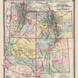

1875 County Map of Colorado, Utah, New Mexico, and Arizona
The Vintage Map Shop
Regular price $35.00
Unit price per
By: Warner & Beers
Date of Original: 1875 (Published) Chicago
Original Size: 16.5 x 14.5 inches (42 x 37 cm)
This is a fine print reproduction of the four-corners states, Colorado, Utah, New Mexico, and Arizona by Warner & Beers, published out of Chicago in 1875.
The map is color coded by county and includes a wealth of interesting historical content and cartographic detail. Much of this region had previously been part of a variety of larger territories such a New Mexico and Utah, Over the years these territories shifted and changed until they became what is known today and displayed in this map from 1875. Many of the counties shown in this map will be further divided and rearranged in years to come.
Interesting cartographic notes include the locations of several Native American tribes including the Navajo, Pueblo, Apaches, Mojaves, Tontos, and Capote to name a few. Completed railroads in Colorado extend into proposed railroads that would one day run through New Mexico and Arizona. Other historical landmarks include several military forts and outposts, silver and copper mines, the site of the Massacra of Captain Gunnison, and the updated delineation of the Colorado River through the Grand Canyon from the Powell expedition of 1869.
Inventory #NA158
About Our Prints
Our prints are fine art reproductions created from original antique maps and vintage posters in our collection, dating back to over 500 years. Each image is professionally scanned, in some cases digitally restored, and carefully printed to preserve the detail, tone, and character of the original work.
- Printed from original maps and prints in our collection
- High-resolution scans for exceptional clarity and detail
- Produced on premium archival paper for long-lasting quality
- Rich color and sharp definition suitable for framing
- Includes a 0.25 inch margin for trimming or matting
- Made to order and securely packaged for safe delivery
Returns and Exchanges
Our prints are made to order, so returns and exchanges are handled within a simple 14-day window. If you need to return or exchange a print, we ask that it be sent back in its original, undamaged condition.
- Returns accepted within 14 days of delivery
- 25% restocking fee on non-damaged returns. Due to lack of storage, larger sizes may incur a higher restocking fee, up to 50%.
- Buyer pays return shipping
- Refunds issued to the original payment method
- Size exchanges available, with shipping and applicable fees paid by the buyer