


1890 New Map of Kyoto's Famous Places
The Vintage Map Shop, Inc.
Regular price $45.00
Unit price per
Map Maker: Cho'oka Kenzou Printed by: Fufetsu Shozaemon
Date of Original: February 1, 1890
Original Size: 20 x 29 inches (51 x 73.5 cm)
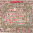
A fine print reproduction of an impressive late 19th-century map of Kyoto, Japan made with the city's long history and recent past both in mind. Designed for the 'walking tourist,' the map specifically lists famous places and other buildings of interest, such as textile mills and silk factories. The map is oriented to the East with North to the left.
At the beginning of the Meiji Era the Emperor left his seat in Kyoto and moved to Tokyo which is why the castles and detached palaces are now all have "former" in front of them. This map, printed Meiji 23 (1890) shows the "former Imperial Palace." at the center. Kyoto moved ahead into the new era building brick buildings like Doshisha while also maintaining its rich heritage of shrine and temples as well as building new temples to honor its past.
Districts appear in big bordered red boxes, the smaller yellow boxes are for '"machi," which can be thought of as sub-districts within districts. At table located just below central Kyoto lists bottom lists the "distance of sights from the Sanjo Bridge," which is located above central Kyoto spanning the Kamogawa River. To the north (left) just before the river splits, one can find the Girl's School, Medical School, a spinning factory, silk factory, and a little more to the east, Yoshida Shrine. These sights and many more are depicted in within the border of over 100 images of various sights found throughout the city.
Inventory # 11707
About Our Prints
Our prints are fine art reproductions created from original antique maps and vintage posters in our collection, dating back to over 500 years. Each image is professionally scanned, in some cases digitally restored, and carefully printed to preserve the detail, tone, and character of the original work.
- Printed from original maps and prints in our collection
- High-resolution scans for exceptional clarity and detail
- Produced on premium archival paper for long-lasting quality
- Rich color and sharp definition suitable for framing
- Includes a 0.25 inch margin for trimming or matting
- Made to order and securely packaged for safe delivery
Returns and Exchanges
Our prints are made to order, so returns and exchanges are handled within a simple 14-day window. If you need to return or exchange a print, we ask that it be sent back in its original, undamaged condition.
- Returns accepted within 14 days of delivery
- 25% restocking fee on non-damaged returns
- Buyer pays return shipping
- Refunds issued to the original payment method
- Size exchanges available, with shipping and applicable fees paid by the buyer