1940 The Pageant of the Pacific
the Vintage Map Shop, Inc.
Regular price $45.00
Unit price per
By: Miguel Covarrubias
Date of Original: 1940 (dated) San Francisco, CA
Original Size: Plates I-IV: 24 x 36 inches, Plates V-VI: 16 x 24 inches
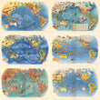
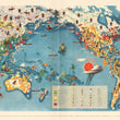
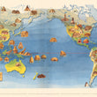
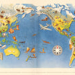
A fine print reproduction of the complete, original set of six maps of the Pageant of the Pacific by Miguel Covarrubias, made for the Pacific House during the 1940 Golden Gate International Exposition held on Treasure Island in San Francisco, CA.
As described within a booklet that accompanied the original set of maps, it's "purpose is to extend the knowledge of countries of the Pacific Basin to create those friendly relations which make a wider understanding of peoples.... Miguel Covarrubias was selected as the one who could make visual the idea of the Pacific Area, not only with the imagination and skill of a great artist, but with an understanding of the verities and needs all peoples hold in common. Covarrubias is an ethnologist and anthropologist, subtle and sensitive to the unrecorded past of unknown peoples, with a humorous, penetrating perspicacity of contemporaneous life, and a wide knowledge of the governmental forms and trade relations, of the moving forces, that bind peoples together or sever their relations."
The portfolio consisted of the following works...
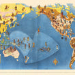
PLATE I. Peoples of the Pacific
- This map aims to build upon what was the old classification system of mankind. At the time of printing, anthropologists divided peoples of the earth into three major groups: Mongoloids, Caucasoids, and Negroids, with endless variations among them. Many of the ethnic groups presented in the map are described as having similar characteristics with groups of people from other reaches of the world. The booklet delves into this subject further and with great detail.
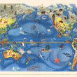
PLATE II. Flora and Fauna of the Pacific
- This map presents the natural biological world of plants and animals that thrive within the varying climates and geographic regions of the Pacific. With a wade range of latitude, ocean temperatures, direction of currents, and topography, the Pacific Basin lends itself to providing a diverse existence of flora and fauna, which are shown in a pictorial fashion as well as varying colors representing types of vegetation. As noted in the booklet, "domesticated animals and cultivated plants are not shown here since they would belong in an economic map.
PLATE III. Art Forms of the Pacific
- This map aims to show the variety of art created by indigenous people of the Pacific, both modern and ancient. The map illustrates authentic examples of indigenous art with an attempt to show works that embody the staple characteristics used by their creators and place them within their region of origin. The booklet notes an attempt (that was never realized) to divide the land areas into cultural areas, but passed on the idea as their vague borders would indicate the spread of these cultures. Each piece depicted within the map is described in the accompanying booklet.
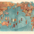
PLATE IV. Economy of the Pacific
- This map was created with an emphasis on the varying types of economic characteristics of the people, their predominant manner of land utilization, and goals of productions, be it for local or export use and the need for basic products. Economic sectors presented in the map include, manufacturing, agriculture (grains, livestock, fisheries), mining, and entertainment. An elaborate index key helps to discern the various industries and the types of regions in which their are supplied.
PLATE V. Native Dwellings in the Pacific Area
- The map provides us with a better understanding of the wide variety of dwellings found among indigenous peoples of the Pacific. A number of factors influence how they came about, including, types and availability of raw materials, climate, tribal traditions, cultural connections, and the overall purpose of the structure. While some dwellings were seasonal or temporary as in the case of nomadic tribes, others were far more permanent. Some dwelling were made for individual families, while others were large enough to house entire tribes or large swaths of the community.
PLATE VI. Native Means of Transportation in the Pacific Area
- In examining the various means of transportation, one realizes the inventiveness of people to get from one place to another utilizing their local resources to conquer the terrain that surrounds them. From vast ocean expanses, to great plains, towering mountains, and a wide range of temperatures found in the arctic , equator, and everywhere in between, humans in every part of the world have adopted their own method of transportation. While Eskimos, Mongolians, and people of India and Indo-China utilize the power of domesticated animals (sled dogs, horses, oxen, and elephants), Island natives of Polynesia, Micronesia, and people along every coast have mastered the art of sailing and paddle powered boats of all shaped and sizes.
Miguel Covarrubias (1904 - 1957) was a Mexican painter, caricaturist, illustrator, ethnologist and art historian. In 1924, at the age of 19, Covarubbias went to New York, funded by a grant from the Mexican government to meet with the literary and illustrative elite. Though his English was very poor, his artistic ability could not be overlooked and he eventually earned a spot as one of the primary cartoonists for Vanity Fair. He later flourished as an artist doing set designs and costumes for plays, a wide array of caricature works and eventually was commissioned to paint six murals for the Golden Gate International Exposition from which these prints were published.
Inventory #11510 (1-6)


