


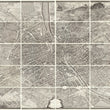

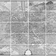


1734-36 The Turgot Plan of Paris | Peel & Stick Wall Mural
the Vintage Map Shop, Inc.
Regular price $375.00
Unit price per
Plan de Paris. Commencé l'année 1734. Dessiné et gravé sous les ordres de Messire Michel Étienne Turgot, Marquis de Sousmons…
By: Michel-Étienne Turgot & Louis Bretez
Date of Original: 1739 (published) Paris
Original Size: 102.5 x 130 inches (260 x 330 cm)
This is a fine print wall covering of a monumental twenty sheet map of Paris that is widely considered to be one of the most impressive bird’s eye view of a city every created. It all began in 1734, when Michel-Étienne Turgot, chief of the municipality of Paris commissioned Michel-Étienne Turgot to create a statement piece to be presented to foreign and domestic dignitaries intended to boast the architecture and layout of the historic city.
In order to achieve this, Turgot was given special permission to enter private mansions, houses, and gardens to take measurements and make sketches so that the finished work would be as accurate as if viewed from the sky in a balloon. The entire process took two years of consistent work followed by the exemplary engraving talents of Claude Lucas of the Royal Academy of Sciences.
The end result of these unique efforts is a spectacular map of Paris, comprised of twenty individual sheets that when joined together creates a dramatic visualization of one of the most iconic cities of the world.
#81042
NOTE: THIS MAP IS ONLY AVAILABLE AS A PEEL & STICK WALL MURAL.
About Our Prints
Our prints are fine art reproductions created from original antique maps and vintage posters in our collection, dating back to over 500 years. Each image is professionally scanned, in some cases digitally restored, and carefully printed to preserve the detail, tone, and character of the original work.
- Printed from original maps and prints in our collection
- High-resolution scans for exceptional clarity and detail
- Produced on premium archival paper for long-lasting quality
- Rich color and sharp definition suitable for framing
- Includes a 0.25 inch margin for trimming or matting
- Made to order and securely packaged for safe delivery
Returns and Exchanges
Our prints are made to order, so returns and exchanges are handled within a simple 14-day window. If you need to return or exchange a print, we ask that it be sent back in its original, undamaged condition.
- Returns accepted within 14 days of delivery
- 25% restocking fee on non-damaged returns
- Buyer pays return shipping
- Refunds issued to the original payment method
- Size exchanges available, with shipping and applicable fees paid by the buyer